219 lines
7.1 KiB
Markdown
Executable File
219 lines
7.1 KiB
Markdown
Executable File
Leaflet.StyledLayerControl
|
|
===================
|
|
|
|
### What is Leaflet.StyledLayerControl?
|
|
A [Leaflet](https://github.com/Leaflet/Leaflet) plugin that implements the management and control of layers by organization into categories or groups. The StyledLayerControl class extends the original L.control.layers control.
|
|
The plugin uses HTML5 and CSS3 to style the presentation in a modern way.
|
|
The initial ideas were based in the plugin: [Leaflet.Groupedlayercontrol](https://github.com/ismyrnow/Leaflet.groupedlayercontrol)
|
|
|
|
|
|
|
|
*Tested with Leaflet 0.7.3*
|
|
|
|
### Main features
|
|
|
|
- Organization of the layers into groups or categories. The layers can be an overlay or basemap
|
|
- Groups may appear initially expanded or not
|
|
- Groups can be opened exclusively
|
|
- A layer can be defined as removable
|
|
- The main container control behaves responsively, automatically adjusting the vertical resizing the map and the screen
|
|
|
|
### Live Demos
|
|
|
|
- [A map using StyledLeafletControl - not exclusive group select](http://davicustodio.github.io/Leaflet.StyledLayerControl/examples/example1.html)
|
|
- [A map using StyledLeafletControl with exclusive group select](http://davicustodio.github.io/Leaflet.StyledLayerControl/examples/example2.html)
|
|
|
|
### How to use?
|
|
|
|
|
|
1 - Create the reference to Leaflet
|
|
```javascript
|
|
<link rel="stylesheet" href="http://cdn.leafletjs.com/leaflet-0.7.3/leaflet.css" />
|
|
<script src="http://cdn.leafletjs.com/leaflet-0.7.3/leaflet.js"></script>
|
|
```
|
|
|
|
2 - Insert references to styledLayerControl.css and styledLayerControl.js
|
|
```javascript
|
|
<link rel="stylesheet" href="../css/styledLayerControl.css" />
|
|
<script src="../src/styledLayerControl.js"></script>
|
|
```
|
|
|
|
3 - Define your layers (base maps and overlays)
|
|
```javascript
|
|
|
|
// Google layers
|
|
var g_roadmap = new L.Google('ROADMAP');
|
|
var g_satellite = new L.Google('SATELLITE');
|
|
var g_terrain = new L.Google('TERRAIN');
|
|
|
|
// OSM layers
|
|
var osmUrl='http://{s}.tile.osm.org/{z}/{x}/{y}.png';
|
|
var osmAttrib='Map data © <a href="http://openstreetmap.org">OpenStreetMap</a> contributors';
|
|
var osm = new L.TileLayer(osmUrl, {attribution: osmAttrib});
|
|
|
|
// ... more Base Maps
|
|
|
|
// Sao Paulo Soybeans Plant
|
|
var soybeans_sp = new L.LayerGroup();
|
|
L.marker([-22, -49.80]).addTo(soybeans_sp),
|
|
L.marker([-23, -49.10]).addTo(soybeans_sp),
|
|
L.marker([-21, -49.50]).addTo(soybeans_sp);
|
|
|
|
// Rio de Janeiro Corn Plant
|
|
var corn_rj = new L.LayerGroup();
|
|
L.marker([-22, -43.20]).addTo(corn_rj),
|
|
L.marker([-23, -43.50]).addTo(corn_rj);
|
|
|
|
// ... more Overlays
|
|
```
|
|
|
|
4 - Create the Leaflet Map Object and add the layer that will be default basemap
|
|
```javascript
|
|
var map = L.map('map', {
|
|
center: [-16, -54],
|
|
zoom: 4
|
|
});
|
|
|
|
map.addLayer(g_roadmap);
|
|
```
|
|
|
|
5 - Define structure of groups and layers of basemap
|
|
```javascript
|
|
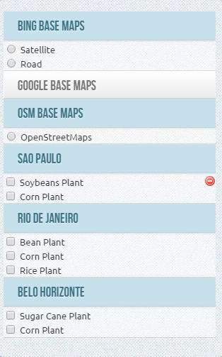
var baseMaps = [
|
|
{
|
|
groupName : "Google Base Maps",
|
|
expanded : true,
|
|
layers : {
|
|
"Satellite" : g_satellite,
|
|
"Road Map" : g_roadmap,
|
|
"Terreno" : g_terrain
|
|
}
|
|
}, {
|
|
groupName : "OSM Base Maps",
|
|
layers : {
|
|
"OpenStreetMaps" : osm
|
|
}
|
|
}, {
|
|
groupName : "Bing Base Maps",
|
|
layers : {
|
|
"Satellite" : bing1,
|
|
"Road" : bing2
|
|
}
|
|
}
|
|
];
|
|
```
|
|
|
|
5 - Define structure of groups and layers of overlays
|
|
```javascript
|
|
var overlays = [
|
|
{
|
|
groupName : "Sao Paulo",
|
|
expanded : true,
|
|
layers : {
|
|
"Soybeans Plant" : soybeans_sp,
|
|
"Corn Plant" : corn_sp
|
|
}
|
|
}, {
|
|
groupName : "Rio de Janeiro",
|
|
expanded : true,
|
|
layers : {
|
|
"Bean Plant" : bean_rj,
|
|
"Corn Plant" : corn_rj,
|
|
"Rice Plant" : rice_rj
|
|
}
|
|
}, {
|
|
groupName : "Belo Horizonte",
|
|
layers : {
|
|
"Sugar Cane Plant" : sugar_bh,
|
|
"Corn Plant" : corn_bh
|
|
}
|
|
}
|
|
];
|
|
```
|
|
|
|
6 - Declare which layers can be deleted and visible (create the removable property with true in the options StyledLayerControl that can be created in the layer object).
|
|
Each layer declared as removable = true will show an icon to delete the user to remove the layer
|
|
```javascript
|
|
soybeans_sp.StyledLayerControl = {
|
|
removable : true,
|
|
visible : false
|
|
}
|
|
// ... more layers
|
|
```
|
|
|
|
7 - Define the options for StyledLayerControl
|
|
- container_width - define the main container width - the default is automatic width
|
|
- container_maxHeight - define the max height to the main container - the default is automatic depending of map and screen height
|
|
- group_maxHeight - define the max height space of group container - the default is 100px
|
|
- exclusive - define that the opened group is exclusive
|
|
|
|
- All the properties are optional
|
|
- You can also include all properties available under "Options" of control L.control.layers in the same list
|
|
|
|
```javascript
|
|
var options = {
|
|
container_width : "300px",
|
|
container_maxHeight : "350px",
|
|
group_maxHeight : "80px",
|
|
exclusive : false
|
|
};
|
|
```
|
|
|
|
8 - Create the StyledLayerControl
|
|
```javascript
|
|
var control = L.Control.styledLayerControl(baseMaps, overlays, options);
|
|
map.addControl(control);
|
|
```
|
|
|
|
### How to add and remove layers and groups dynamically ?
|
|
|
|
- To add a new base layer dynamically, simply use addBaseLayer and declare that the group layer will belong.
|
|
Also note that to add a new group, simply specify a group name that does not exist yet, and a new group will be created.
|
|
```javascript
|
|
control.addBaseLayer( bing1, "Bing Satellite", {groupName : "Bing Maps", expanded: true} );
|
|
control.addBaseLayer( bing2, "Bing Road", {groupName : "Bing Maps"} );
|
|
```
|
|
|
|
- To add a new overlay layer dynamically, simply declare the group that de layer will belong.
|
|
```javascript
|
|
control.addOverlay( corn_bh, "Corn Plant", {groupName : "Belo Horizonte"} );
|
|
```
|
|
|
|
- To remove a layer dynamically, specify the instance variable of the layer using the method removeLayer. (the method ignore the removable property of layers )
|
|
```javascript
|
|
control.removeLayer( corn_sp );
|
|
```
|
|
|
|
- To remove a group, specify the name of the group in the removeGroup method.
|
|
By doing so all layers belonging to the group will also be excluded
|
|
```javascript
|
|
control.removeGroup( "Rio de Janeiro");
|
|
```
|
|
|
|
### How to select and unSelect layers dynamically ?
|
|
|
|
- To force select a layer dynamically, simply use selectLayer function like this :
|
|
```javascript
|
|
control.selectLayer( corn_sp );
|
|
```
|
|
|
|
- So.. to un-select the layer :
|
|
```javascript
|
|
control.unSelectLayer( corn_sp );
|
|
```
|
|
|
|
### How to select and unSelect group layers dynamically ?
|
|
- To force select all layer of a group, use like this :
|
|
```javascript
|
|
control.selectGroup( "Rio de Janeiro" );
|
|
```
|
|
|
|
- So.. to un-select the all layer of group :
|
|
```javascript
|
|
control.unSelectGroup( "Rio de Janeiro" );
|
|
```
|
|
|
|
|
|
### License
|
|
<a rel="license" href="http://creativecommons.org/licenses/by/3.0/deed.en_US"><img alt="Creative Commons License" style="border-width:0" src="http://i.creativecommons.org/l/by/3.0/88x31.png" /></a><br />This work is licensed under a <a rel="license" href="http://creativecommons.org/licenses/by/3.0/deed.en_US">Creative Commons Attribution 3.0 Unported License</a>.
|